Whose round is it anyway?
If you just want to see the hills and schedule, scroll down to the bottom! For my ramblings, get a cup of brown water and a Vimto bar and read on....
What we really need is an extended 15 trigs with more hills and proper Peak terrain. And hallelujah, that is exactly what James Lowe came up with! James made a rough map of the route and posted on Facebook, so after a few weeks of looking and wondering I decided to have a crack at it on Friday.
I left the Sportsman at midnight and after an initial false start (wrong direction... let's call it a warm up) I set of on the familiar route to Rod Moor. Heading over towards Emlin I took a detour to try to avoid waking a farmer (via waking his cows), but the detour was a disaster and as I clambered through Royd's Clough I wished I'd not bothered! Eventually I rejoined my route and started to climb to trig 2. It was a sticky humid night, it didn't drop below about 26'C till well into the morning.
With all the built-up heat I was treated to a spectacular and occasionally terrifying lightning storm overnight. From one side the whole sky would light up in a huge flash, quickly followed by forks of lightning reaching down to the ground from the other side, then another flash from behind. I tried to keep track of the time between lightning and thunder as I was now on the exposed ground of Emlin, Cartledge Ridge and Back Tor, but with so many different sources it was hard to match the right sound to the right light! I wondered if I was being a total idiot and considered turning around, but each time the storm subsided just before I saw sense, so I kept going and survived till it faded into the morning.
By the time I reached the first road crossing after about 4:35 it was starting to get light. I did not feel as sprightly as I'd hoped. With the heat and humidity I hadn't eaten much so I shoved half a bag of sweets into my face. Part of the problem was water - I would be drinking stream water all day and after the hot weather I knew it would be a bit dodgy, so I took a stash of water purification tablets with me. The problem is that they take half an hour to work properly, so by the time the water was clean I was gasping, meaning I drank most of it straight away and was back to searching for streams.
Leg 4: 23km (~4:00)
Start: Tintwistle PO
13 Cock Hill
14 Higher Shelf Stones
15 Alport
End: A57 Alport Bridge
Leg 5: 30km (~5:30)
Start: A57 Alport Bridge
16 Blackden
17 Sandy Heys
18 Harry Hut
19 Kinderlow
20 Brown Knoll
End: Mam Tor CP
Leg 5: 30km (~4:00)
Start: Mam Tor CP
21 Mam Tor
22 Win Hill
23 High Neb
24 Crowper Stone
25 Ox Stones
Finish: Sportsman Inn
The Peak District Round
Over the years lots of us have wondered whether there should be a 24 hour round in the Peak District, or at least why there isn't one. I've had a couple of goes at finding one: The first became a 28-hour death march and ended with imaginary green bunnies (here for more details). The second was an attempt to combine the classic Dark Peak 15 trigs with the lesser-known 11 trigs in the White Peak. Pete Simpson combined the two in 1991, but made a mistake and added Flask Edge too (hopefully winning him the Pertex Trophy?!). I hoped to retain Pete's folly and add another trig, but on the day only managed to add Ox Stones (words about this one here). This took 23:42 and was slightly over 100 miles, giving us a viable 27 trig "Peak BG", but the White Peak 11 don't make for a nice route - there's too much road and too much trespass. Dark Peak runners don't like road...What we really need is an extended 15 trigs with more hills and proper Peak terrain. And hallelujah, that is exactly what James Lowe came up with! James made a rough map of the route and posted on Facebook, so after a few weeks of looking and wondering I decided to have a crack at it on Friday.
 |
| The startline: A wall gap next to the club hut. |
With all the built-up heat I was treated to a spectacular and occasionally terrifying lightning storm overnight. From one side the whole sky would light up in a huge flash, quickly followed by forks of lightning reaching down to the ground from the other side, then another flash from behind. I tried to keep track of the time between lightning and thunder as I was now on the exposed ground of Emlin, Cartledge Ridge and Back Tor, but with so many different sources it was hard to match the right sound to the right light! I wondered if I was being a total idiot and considered turning around, but each time the storm subsided just before I saw sense, so I kept going and survived till it faded into the morning.
 |
| Lightning over Manchester (Photo: Martin Casey / M.E.N.) |
 |
| Mmmm water. (NB: Poetic license applied in the use of this photo) |
Anyway, after eating a bit better and consuming more chlorine than the first time I went swimming, I felt a bit better. I've not visited South Nab since the first Peak District 24 hour thing (the one with the bunnies), so it was nice to be there again. From here to Dead Edge End, Snailsden Pike End and ultimately the next road crossing, it's all about tussocks. If you're not familiar, here is a diagram:
 |
| "Tussocks". Walker, 2019. Pencil on book. |
They are certainly not unique to the Peak District, but we do have some good ones, and I found them really hard work this time. There is a brief section of respite between the Trans-Pennine Trail and Woodhead Tunnels, but after that it's full on tussock-bashing over the wonderfully named Twizle Head Moss till you end up at Holme Moss. To here took me about 6 and a half hours, it's about 42km and mercifully it had cooled down a bit.
Next comes the ascent of Black Hill, which will cause you no problems, then a lovely section of Pennine Way over to Featherbed Moss. Here I realised I should take the opportunity and managed a couple of mega speedy (6 minute) kilometres! I really enjoyed this section, and the next part up to Alphin Pike. Memories of joining my friend Chris Webb for one of his 25 ascents of the hill for charity returned as I reached the top. Check the link for a spelling masterclass.
 |
| Chris in 2015. He had gone by I got there. |
After Alphin it's time to turn around, sort of. The descent takes you through a quarry and around the edge of Mossley, then just when you think you're about to head east there's the surprisingly steep and tough climb up Wild Bank. The direct line I'd planned was impossible, so I contoured round to the west then climbed up the fence line. It was hot again and I didn't fancy any of my food. What I wanted was Coke. Lots and lots of Coke.
Fortunately, the final bit of this leg (though you could call Mossley the end of the leg if you wanted) takes you through Moorside Farm, around Arnfield Reservoir and into Tintwhistle. There's an alternative route via Hardtimes Farm, but I was whinging enough already...
Tintwhistle Post Office. If you need a 3 litre bottle of Strongbow at 10am on a Friday, it's the shop for you! The man in front of me did, so he was pleased. But not as pleased as I was with two bottles of Coke, a Double Decker multipack and three Vimto bars. Yes, Vimto bars:
 |
| Who needs gels? 10p and all the sugar. |
Feeling refreshed, with clean water thanks to the lady in the shop and a pat on the back from cider man (unfortunate for him) I set off with renewed vigour. Well, I walked for about a kilometre while a litre of Coke had an argument with my stomach, THEN I set off with renewed vigour.
As I completed the longest road section of the whole round I realised this probably has less total tarmac than the Bob Graham. Next comes Cock Hill (stop it). Here I had to take an extended route around some Ostriches, which means you'd actually be best to turn right onto the footpath before Swineshaw Res, like this:
 |
| Possibly better route to Cock (stop it) Hill. |
I reached the top after about 11 hours 40 mins. With 13 trigs done in just under 12 hours completion was by no means certain, so I pressed on to Higher Shelf Stones, then via another round of tussocks around the top of the Alport river to head down the north-eastern side of this amazing valley to trig 15. There were a few people about as I headed down to Alport Castles, amazingly the first I'd seen on the hill since starting! I filled up on yummy brown water again as I crossed the river at Alport Farm then jogged down the track to the road crossing.
 |
| Somewhere near Alport Bridge. |
Now I was getting back into home ground, or at least hills I'd heard of! From Upper Ashop Farm I initially took the Kinder Dozen line, but it's horrible however you do it. A lot of the climb in this route comes in the later stages, but at least there is some slightly easier ground later on. From Blackden you're on the Kinder section, which means it's spectacular, beautiful, and very easy to trip over with tired shuffly feet. Fairbrook Naze can be seen from miles away and it seemed to take forever to get there, but I was enjoying this. Only the spectre of Harry Hut hung over me. Apart from the little one to Back Tor, this is the only out-and-back on the route, but it's also and down-up-down,up-down-up.
At Sandy Heys I ate some more food, decided not to leave my pack and set off to see Harry. I was actually feeling good uphill so I jogged to the top of Mill Hill, then made my way down to the turnaround. I walked the uphill on the way back and sent Lorna a text to say I'd be close to 24 hours. I really had no idea if it was possible or not - I got to Kinder Downfall after 18:20 (110km ish) with 7 trigs to go...
 |
| Harry Hut: Tuurn aroound briight eeyes. |
Now it feels like you're on the way home (unless you're going clockwise of course). After the downfall, Kinderlow and Brown Knoll are easily ticked off, then as you come off Brown Knoll onto the interminable flagstones you'll feel like you're doing the High Peak Marathon again. Heaven forbid.
 |
| Sorry. |
Here I really tried to keep moving at a decent pace. Looking at the number of trigs done, I thought I was on pace to scrape under 24 hours, but the distance said otherwise. Basically I needed to speed up!
I nearly made a stupid mistake by trying to cut the corner onto Rushup Edge, but just in time realised I'd be much better off adding 200m than bashing across more tussocks for 500. I forced a jog up to Lord's Seat, then down the other side to the road crossing just before Mam Tor. Just under 20 hours had gone as I passed through the last road crossing. If you've got road support you could add another in Hope but I'd suggest you just crack on.
I was now in full "get me home" mode: There was a short but very wet shower as I set off up Mam Tor which was lovely which revived me a bit, and after Hollins Cross and skirting Lose Hill I refilled one of my bottles in Hope and prepared for Twitchill Farm.
 |
| Urgh. |
The tarmac road up to the farm is probably my least favourite part of the Peak District. It's steep but really should be runnable, which means you either hurt because you're running or feel guilty because you're not. This time it was half of each. Once you're through the farm though, it's too steep to do anything other than a good solid powerwalk. My legs felt OK but I was starting to go a bit loopy. I remember seeing a couple leaning on the fence taking photos just below Win Hill. As I got closer I said Hello and explained I was glad to see some real people, as for the last hour or so I'd kept thinking I had seen people, but they'd turned out to be fenceposts! How we laughed.
On closer inspection, they were also fenceposts.
 |
| Evenin' |
After a slow descent of Parkin Clough, and a final top-up at the bottom I started the next possibly runnable climb up. I hope you don't need to run it, but I did need to. I just about kept going to the stile off towards High Neb, then fought through the bracken and scrambled up to pop out a few metres from the trig after 22:22.
An hour and a half to get to the Sportsman from here should be easy, but our route doesn't go straight there. After dropping off the top we don't take the left to Stanage Pole, but go right and along Stanage via the Crowper Stone to Burbage. To stop me drifting off I decided to have a sensible conversation with myself - I explained my PhD, discussed the Tour de France and described each of the trig points I'd been to. Sensibility took me to Burbage Bridge, where I'd been wondering which way to go. I've never really found a good trod from there to the Ox Stones, but rather than run along the road (very anti DP ethos) I tried once more.
 |
| It's on the internet so it must be true. |
To my delight it worked, there was a trod and by 23:30 I was at the stones. 25 trigs done. The run in from here is simple provided it's light, and you're awake and concentrating. I went too far left before Brown Edge Farm and started heading across to White Stones, but eventually found my way back and through the farm. NOW I knew I couldn't get lost: Left at the road (23:42), down Roper Hill (23:46), right then left (23:51) on the footpath and across the field back to the pub. Look out for those picnic benches.
Phew! 23:55.
What a route. I'm dead chuffed to have finished it, no doubt with lines that will make many of you giggle, so I look forward to seeing others do it and take hours off my time. I might even have another go once you've all worked out the best route and put some trods down...
 |
| Whose round is it anyway? |
Mega thanks to James Lowe for coming up with a really great route. I think it should be called the James Lowe Round and James thinks it should be called my name, but anyway, the important thing is that it is a Peak alternative to the BG, and I hope lots of people will give it a go, starting with my Dark Peak clubmates. I'd be delighted to help anyone if I can. It's great, you should do it.
I couldn't have tried without the help of Lorna (who was there when I finished, having pretty much hid in the car while some dodgy things went on in the car park - sorry and thank you!), Stu Hale, the Flamingos, everyone at Accelerate and Scott. Thank you all.
 |
Serious factual numbers and lists of stuff.
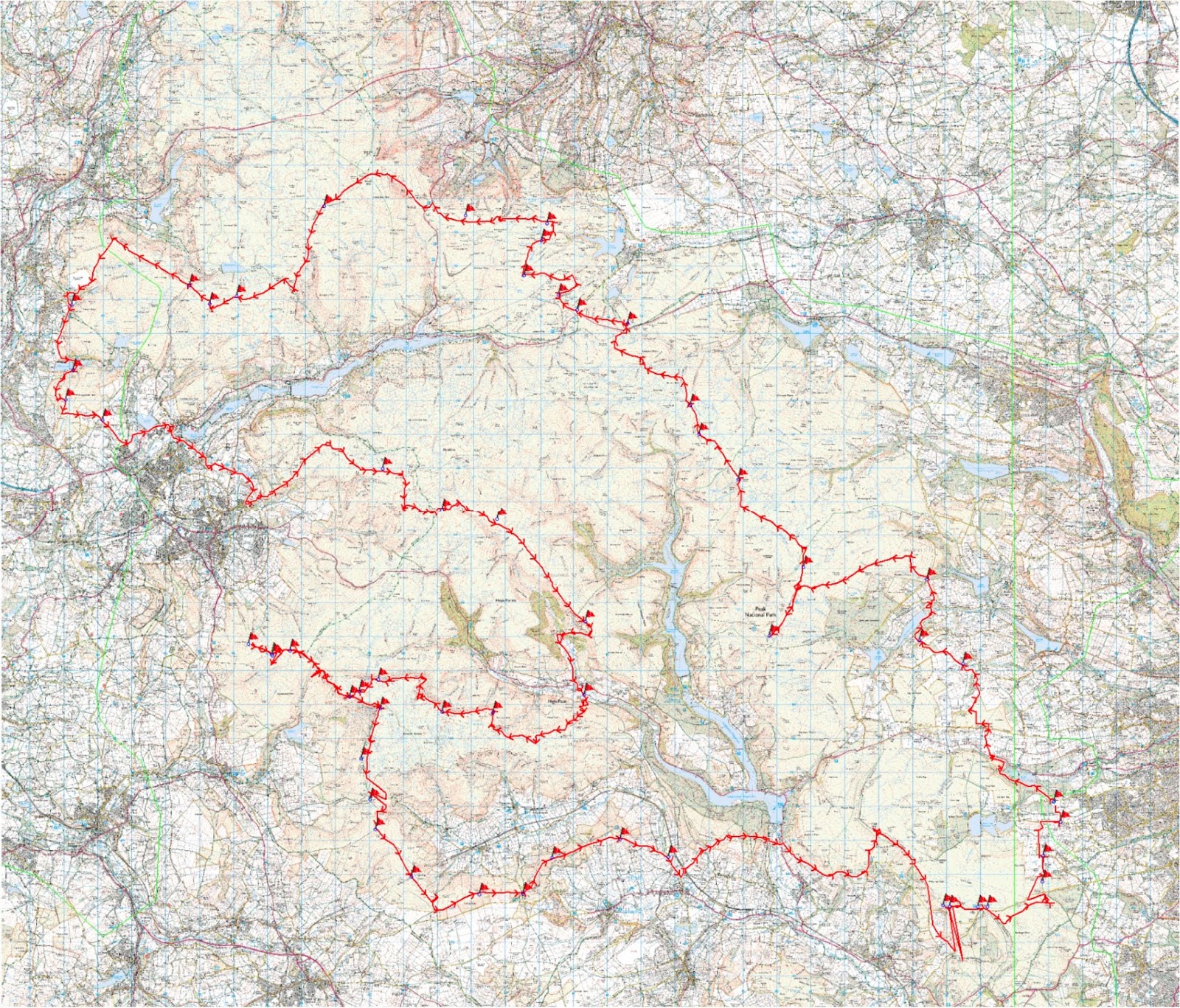
James' rough route: OS
My route: Movescount or Strava
(Some GPS glitches due to 10 second setting but the distances below are corrected for these)
Legs and schedule for 23:45 round.
Approximate times and no allowance for actually stopping!
Leg 1: 31km (~4:30)
Start: Sportsman Inn, Lodge Moor
1 Rod Moor
2 Emlin
3 Back Tor
4 Margery Hill
5 Outer Edge
End: A628 (156003)
Leg 2: 13km (~2:00)
Start: A628
6 South Nab
7 Dead Edge End
8 Snailsden Pike End
End: A6024 (Holme Moss)
Leg 3: 23km (~3:45)
Start: Holme Moss
9 Black Hill
10 Featherbed Moss
11 Alphin Pike
12 Wild Bank
End: Tintwistle PO
Leg 4: 23km (~4:00)
Start: Tintwistle PO
13 Cock Hill
14 Higher Shelf Stones
15 Alport
End: A57 Alport Bridge
Leg 5: 30km (~5:30)
Start: A57 Alport Bridge
16 Blackden
17 Sandy Heys
18 Harry Hut
19 Kinderlow
20 Brown Knoll
End: Mam Tor CP
Leg 5: 30km (~4:00)
Start: Mam Tor CP
21 Mam Tor
22 Win Hill
23 High Neb
24 Crowper Stone
25 Ox Stones
Finish: Sportsman Inn


Comments
Post a Comment